New Indian-Chennai News + more

Members Login
Username 
 
Password 
    Remember Me  
Post Info TOPIC: Hindu Kings Of Iraq Turkey Syria Lebanon Egypt Italy Mitanni Empire


Guru

Status: Offline
Posts: 24601
Date:
Hindu Kings Of Iraq Turkey Syria Lebanon Egypt Italy Mitanni Empire
Permalink  


Hindu Kings Of Iraq Turkey Syria Lebanon Egypt Italy Mitanni Empire

https://ramanan50.wordpress.com/2015/06/12/hindu-kings-of-iraq-turkey-syria-lebanon-egypt-italy-mitanni-empire/?fbclid=IwAR12SfM52XaU8AUULbK2f5F_9I75InB49s2GGetzARIeTySumX5LE8sG2pQ

I have written about the Mitanni People and the Mitanni Empire.

The Mitanni Empire covered what is now known as Iraq, Turkey Syria, Lebanon,Egypt and included Italy.

They were the ancestors of these people.

Mitanni were the ancestors of the Egyptians as well.

Mittani Empire.pngMittani Empire. “Near East 1400 BCE” by User:Javierfv1212 – http://en.wikipedia.org/wiki/File:Near_East_1400_BCE.png. Licensed under CC BY-SA 3.0 via Wikimedia Commons – http://commons.wikimedia.org/wiki/File:Near_East_1400_BCE.png#/media/File:Near_East_1400_BCE.png

 ‘These Kings and even a Roman Emperor sported Thiruman, The Vaishnavite marks on their Body.

 The Sun King Akhenaten of Egypt who ruled between 1352-1336 BC was a son-in-law of Tushratta, the Mitanni king. The name Tushratta has been recorded in the Hittite cuneiform script.

 Some have suggested that the Sanskrit origin of Tushratta is Dasaratha, a few others that it is Tvesaratha (having splendid chariots), a name which is attested in the Rigveda.

“The first Mitanni king was Sutarna I (good sun). He was followed by Baratarna I (or Paratarna great sun), Parasuksatra(ruler with axe),…. Saustatar (Sauksatra, son of Suksatra, the good ruler), Artadama (abiding in cosmic law)..Tushratta (Dasaratha), and finally Matiwazza (Mativaja, whose wealth is thought) during whose lifetime the Mitanni state appears to have become a vassal to Assyria”. Subhash Kak traces the ‘arna’ syllable in the names of the kings to ‘araNi’ (अरणि) meaning ‘sun’…

(Akhenaten, Surya, and the Rigveda’, Prof Subhash Kak (an Indian American computer scientist, previous Head of Computer Science Department, Oklahoma State University)

 “A number of Indo-European sounding words have been identified in the cuneiform documents of the Mitanni kingdom (1500-1200 BC). In addition to nouns and adjectives with parallels in Sanskrit this Hurrian speaking kingdom had kings with Indo-Aryan names and two documents even list the main Gods of the Indian pantheon….”


The kingdom of the Mitanni Indo-Iranian dynasty that ruled in the land of the Hurrians was in the upper Euphrates-Tigris basin – land that is now part of northern Iraq, Syria and south-eastern Turkey.

At its greatest extent (for a brief period at the height of its dynastic power), Mitanni territory extended to the Mediterranean coast and into northern Assyria / Mesopotamia, it’s south-eastern neighbour.

Mitanni’s north-western border with theHattian kingdom of the Hittites was fluid and constantly subject to aggression except when the two rivals concluded a peace treaty – one that invoked the Indo-Iranian pantheon of Mitra, Varuna, Indra and the Nasatyas – but also one that marked the decline of the Mitanni kingdom and a decrease in size. The Mitanni and Hittites were closely related. The Hittites used the Hurrian language extensively in their inscriptions. They also shared in the development of the light chariot whose wheels used spokes .

The Hurrian lands are today a part of Greater Kurdistan….


Despite Tusratta’s problems, he was not beyond offering his daughter Tadukhipa in marriage to the King Amenhotep III of Egypt for a large quantity of gold. The tablet seen to the right is a letter from Tusratta to Amenhotep in which he asks for “gold in very great quantity” as a bride price, supporting his request with the comment, “Gold is as dust in the land of my brother.”

The beleaguered Tusratta was then murdered by his son in a palace coup. Tusratta’s other son, Prince Shattiwaza, fled Mitanni and was eventually given sanctuary by the Hittite King Suppiluliuma with whom he concluded a treaty c. 1380 BCE, which we know as the Suppiluliuma-Shattiwaza Treaty (discovered in 1907 CE in Hattusa, near present-day Bogazkale(Boğazkale, formerly Bogazköy) in north-central Turkey. In the treaty, the Hittite King Suppiluliuma agreed to assist Shattiwaza gain the Mitanni throne and invaded Mitanni. The Hittites captured the Mitanni capital Wassukanni after a second attempt and installed Shattiwaza as a vassal king.

The Suppiluliuma-Shattiwaza Treaty is a source of considerable information about the Mitanni. In addition, it gives us some astonishing information about the religious practices of the Mitanni for it invokes the Indo-Iranian pantheon of asuras and devas Mitras(il) (Mitra)Uruvanass(il) (Varuna)Indara (Indra) and theNasatianna (Nasatyas) (Ashwins).

Following the capture of Wassukanni, the Hittites installed new rulers in Mitanni towns while the Assyrians regained control of the territory they had lost to the Mitanni. Tusratta was killed and his son Shattiwaza became a vassal of the Hittite Suppiluliuma (c.1344 – 1322 BCE). At the same time, the rebellious Artatama became a puppet king of a reborn Assyria, led by king Assur-Uballit I (1364-1328 BCE). Wassukanni was sacked again by the Assyrian king Adad-Nirari I around 1290 BCE, after which very little is known of its history.

In our page on the Hittites, we note:
“In the Bogazkale archives, native Hurrian is used frequently for a wide range of non-official texts such as those on rituals and even the Epic of Gilgamesh – more so than native Hattian. Native Hurrian texts have been found throughout the region. One such text dated to 1750 BCE was found at Tell Hariri (ancient Mari), a Middle Euphrates site, and another at Ras Shamra (Ugarit) on the Syrian coast indicating Hurrian i.e. Mitanni influence in the region preceded the rise of Hittite power. A similar language to Hurrian is the language of Urartu located to the west of the Hittite lands at the headwaters of the Euphrates and around Lake Van. According to the literature (cf. The Hittites by O. R. Gurney, Penguin Books 1981), The Hurrians were migrants to the Upper Euphrates and Habur basin from the Elburz Mountains east across the Taurus Mountains from about 2300 BCE onwards.”

The Mitanni name for chariot warriors was maryanna or marijannina, a form of the Indo-Iranian term marya meaning ‘young man,” used in the Rig Veda when referring to the celestial warriors assembled around the Vedic deity Indra.The Mitanni were famed charioteers. They are reported to have spearheaded the development of the light war chariot with wheels that used spokes rather than solid wood wheels like those used by the Sumerians.

Tushratta's letter to Amenhotep III of Egypt Amarna from Tell el-Amarna. Housed at British Museum WAA 29791.jpgTUSHRATTA’S LETTER TO AMENHOTEP III OF EGYPT AMARNA FROM TELL EL-AMARNA. HOUSED AT BRITISH MUSEUM WAA 29791
THE HITTITE ARCHIVES OF HATTUSA, NEAR PRESENT-DAY BOGAZKALE CONTAINED WHAT IS THE OLDEST SURVIVING HORSE TRAINING MANUAL IN THE WORLD. THE ELABORATE WORK WAS WRITTEN C. 1345 BCE ON FOUR TABLETS AND CONTAINS 1080 LINES BY A MITANNI HORSE TRAINER NAMED KIKKULI. IT BEGINS WITH THE WORDS, “THUS SPEAKS KIKKULI, MASTER HORSE TRAINER OF THE LAND OF MITANNI” AND USES VARIOUS INDO-IRANIAN WORDS FOR HORSE COLOURS, NUMBERS AND NAMES. EXAMPLES ARE:

assussanni a form of the Sanskrit asva-sani meaning ‘horse trainer’,
aika wartanna meaning one turn (cf. Vedic Sanskrit ek vartanam),
tera wartanna meaning three turns (cf. Vedic Sanskrit tri vartanam),
panza wartanna meaning five turns (cf. Vedic Sanskrit panca vartanam),
satta wartanna meaning seven turns (cf. Vedic Sanskrit sapta vartanam), and
navartanna meaning nine turns (cf. Vedic Sanskrit nava vartanam).
[Regrettably, writers do not mention the Old Iranian equivalents.]

A Hurrian text from Yorgan Tepe also uses Indo-Iranian words to describe the colour of horses, words such as babru for brown, parita for grey, and pinkara for a reddish hue.

The Kikkuli manual for training chariot horses highlights the links between the Mitanni and Hittites. Even though they were rivals at times, the two groups also collaborated frequently. The fact that the Hittites employed a Mitanni as a master trainer of horses may indicate that it was the Mitanni who were the regional experts in horse training especially for military purposes (in a manner similar to the Sogdians in the East) and that the Mitanni in turn had brought the expertise with them in their migration westward.

The methods used in the Kikkuli method enabled horses to be trained without injury. The text detailed a 214-day training regime using interval training and sports medicine techniques such as the principle of progression, peak loading systems, electrolyte replacement, fartlek training, intervals and repetitions and was directed at horses with a high proportion of slow-twitch muscle fibres. the Kikkuli horses were stabled, rugged, washed down with warm water and fed oats, barley and hay at least three times per day.

Kikkuli’s interval training technique stressed the leading of horses at a trot, canter and gallop, before subjecting them to the weight bearing stress of a rider, driver or chariot. Workouts sometimes numbered three a day with scheduled rest days. Kikkuli’s interval training contained three stages – the first two for developing strong legs and a strong cardio-muscular system, and the third for increasing neuromuscular conditioning. His workouts included brief recoveries to lower the heart rate. Swimming was also included in intervals of three to five sessions, with rest periods after each session. The horses were also subject to warming down periods and the method’s example of cantering included intermediate pauses to lower the heart rate partially and as the training advanced the workouts included intervals at the canter.

MITANNI INDO-IRANIAN NAMES

The names of the Mitanni kings and their capital city were of Indo-Iranian origin. For instance, Tueratta was a form of the Indo-Iranian Tvesa-ratha meaning ‘Possessor of a Chariot’. The name S’attuara was a form of Satvarmeaning ‘warrior’ and the name of the Mitanni capital Wassukanni, was a form of Vasu-khani meaning ‘wealth-mine’.

The names of proto-Indo-Iranian dieties are also found to form the names of the Kassite rulers of Babylonia.

Arta

Several Mitanni names contained the Old Persian term arta, a derivative of asha via arsha, meaning cosmic order and truth (arta transforms to the Sanskrit r’ta). Arta is found used in Old Persian Achaemenian names (e.g. Artakhshassa c.450 BCE) and in the Sogdian Avesta as well. Asha is the central ethical concept of the Avesta.

Philologists trace the Mitanni names to the Vedic equivalents. For instance, they note that the royal name Artatama was a form of the Indo-Iranian R’ta-dhaanman meaning ‘the abode of rta’, and the name Artas’s’umara was a form of Rta-smara meaning ‘remembering r’ta’.

However, for some reason, none of the writers that we have come across link the name to their Old Iranian or Old Persian equivalents – equivalents that will be closer to the Mitanni names as we have demonstrated with the use of arta above.

 http://www.heritageinstitute.com/zoroastrianism/ranghaya/mitanni.htm#dynasty

Reference and Citation.


__________________


Guru

Status: Offline
Posts: 24601
Date:
Permalink  
 

Ancient Indians in Mitanni. Excerpts from Suppiluliuma (Hittite)-Shattiwaza (Mitanni) treaty, 15th cent. BCE

Mitanni
Hittite Treaty

Image result for mitanni

Image result for mitanniSuppiluliuma (Hittite) -Shattiwaza (Mitanni) Treaty Excerpts

Source: Beckman

KBo 1 1
A Obv. 1-16: When My Majesty, Suppiluliuma, Great King, Hero, King of Hatti, Beloved of the Storm God, and Artatama, king of the land of Hurri, made a treaty with one another, at that time, Tushratta, king of the land of Mitanni, called for attention from the Great King, King of Hatti, Hero. And I, Great King, King of Hatti, Hero, turned my attention to Tushratta, king of the land of Mitanni: I plundered the lands of the west bank of the River [Euphrates] and I annexed Mount Lebanon. A second time King Tushratta was presumptuous to me and spoke as follows: “Why are you plundering on the west bank of the Euphrates?” – thus King Tushratta – “If you plunder the lands of the west bank of the Euphrates, then I too will plunder the lands of the west bank of the Euphrates.” King Tushratta desired to bring it under control(?): “If you plunder them, what will I do to them? If a lamb or if a kid of my land is …, I will cross over from the east bank of the Euphrates”. I, Great King, King of Hatti, maintained my pride before him. In the time of the father of the King of Hatti, the land of Isuwa became hostile, so that the troops of Hatti entered the land of Isuwa. In the time of my father, the troops of the city of Kirtalissa, the troops of the city of Arawanna, the land of Zazia, the land of Kalasma, the land of Timana, Mount Haliwa, Mount Karna, the troops of the city of Turmitta, the land of Alha, the land of Hurma, Mount Harana, half of the land of Tegarama, the troops of the city of Tepurziya, the troops of the city of Hazka, and the troops of the city of Armatana became hostile. But My Majesty. Suppiluliuma, Great King, King of Hatti, Hero, Beloved of the Storm God, defeated them. Now the troops, which had escaped from me, had entered the land of Isuwa and all these troops and these lands, which had become hostile in the time of my father, were dwelling beyond the land of Isuwa among the enemy.

A Obv. 17-24: And, I, My Majesty, Suppiluliuma, Great King, King of Hatti, Hero, Beloved of the Storm God, set out against the presumptuousness of King Tushratta. I crossed the Euphrates and went to the land of Isuwa. For the second time, I overpowered the land of Isuwa and for the second time, I made them my subjects. The troops and lands which in the time of my father entered the land of Isuwa: the troops of the city of Kirtalissa, the troops of the city of Arawanna, the land of Zazisa, the land of Kalasma, the land of Timana, Mount Haliwa, Mount Karna, the troops of the city of Turmitta, the land of Alha, the land of Hurma, Mount Harana, half of the land of Tegarama, the troops of the city of Tepurziya, the troops of the city of Hazka, and the troops of the city of Armatana - these troops and those lands I overpowered and returned to Hatti. I freed the lands which I captured; they dwelt in their places. All the people whom I released rejoined their peoples and Hatti incorporated their territories.

A Obv. 25-29: And, I, My Majesty, Suppiluliuma, Great King, King of Hatti, Hero, Beloved of the Storm God, reached the land of Alši and the district of Kutmar and I overpowered them. I gave it as a gift to Antaratli of the land of Alši. I penetrated to the district of Šuta and plundered the district of Šuta. I reached the city of Waššukanni in search of plunder. I brought to Hatti the cattle, sheep and horses of the district of Šuta, along with its possessions and its civilian captives. But King Tushratta fled. He did not come against me for battle.

Obv. 30-37: I crossed the Euphrates again and overpowered the land of Halab and the land of Mukish. Takuwa, king of Niya, came before me for peace terms in the land of Mukish. But behind the back of Takuwa, his brother, Aki-Teshup, brought the land of Niya and the city of Niya to hostility…I, Great King, King of Hatti, overpowered the city of Arahati. I captured Akiya, king of Arahati; Aki-Teshup, brother of Takuwa; and all of their chariot warriors, together with their possessions, and brought them to Hatti. I also brought the city of Qatna, together with its belongings and possessions to Hatti,….

Obv. 38-47: When I went to the land of Nuhašše, I captured all of its territory. Its king Šarrupši alone escaped but I captured his mother...I installed Takipšarri, subject of Šarrupši, in kingship over the city of Ukulzat. I went to the land Apina, but I did not seek to attack the land of Kinza. But its king Šutatarra, together with his son Aitakama and his chariotry, came against me for battle. I drove him off and they entered the city of Abzuya. I invested Abzuya and I captured Šutatarra, together with ....and brought them to Hatti. I went to the land of Apina and Ariwana, king of the land of Apina, and his noblemen,..came against me for battle. I brought all of these, together with their land and their possessions to Hatti. Because of the presumptuousness of King Tushratta, I plundered all of these lands in one year and brought them to Hatti. From Mt Lebanon and from the far bank of the Euphrates I made them my territory.

Obv 48-58: When his son conspired with his subjects, he killed his father , King Tushratta. And with the death of King Tushratta, the Storm-god decided the legal case of Artatama. His son brought the dead Artatama back to life. The entire land of Mitanni went to ruin and the land of Assyria and the land of Alši divided it between them. Until now, I, great King, Hero, King of Hatti, have not crossed to the est bank and have not taken even a blade of straw or a splinter of wood of the land of Mitanni... …

A Rev 14-21: I, Great King, King of Hatti, captured the land of Mitanni. I did not capture them in the time of Prince [Shattiwaza]; I captured them in the time of Tushratta. The Euphrates [is my frontier (?)]. In my rear, I established Mount Lebanon as my frontier. And all of the cities [of the land of Carchemish – the cities of Carchemish], Murmurik, Shipri, Mazuwati and Šurun – these fortified cities [of the land of Carchemish] – I gave [to Piyassili], my son. All the cities which are situated in the land of Ashtata, on the west bank [of the Euphrates] of the land of Mitanni – Ekalte, … , Ahuna and Terqa – these cities belong to the land of Ashtata. Since Prince Piyassili crossed the Euphrates with [Prince] Shattiwaza and penetrated to the city of Irrite, all the cities on the west bank which Piyassili, [my son] holds – these belong to Piyassili. …

A Rev 35-53: the Storm-god, Lord of Heaven and Earth, the Moon-god and the Sun-god, the Moon-god of Harran, heaven and earth, the Storm-god, Lord of the kurinnu of Kahat, the Deity of Herds of Kurta, the Storm-god, Lord of Uhušuman, Ea-šarri, Lord of Wisdom, Anu, Antu, Enlil, Ninlil, the Mitra-gods, the Varuna-gods, Indra, the Nasatya-gods, Lord of Waššukanni, the Storm-god, Lord of the Temple Platform (?) of Irrite, Partahi of Šuta, Nabarbi, Šuruhi, Ištar, Evening Star, Šala, Belet-ekalli, Damkina, Išhara, the mountains and rivers, the deities of heaven and the deities of earth.

Beckman 6B Version
Obv 31-40: ....From the city of Carchemish where we arrived, we sent a messenger to the people of the city of Irrite, but Shuttarna had influenced the Hurrians with the riches of Tushratta and had united them. We sent to them in Irrite and these Hurrians sent back to Piyassili: “Why are you coming? If you are coming for battle, come, but you shall not return to the land of the Great King!” When we had heard the words of the people of Irrite, we – Prince Piyassili and PrinceShattiwaza – crossed the Euphrates and arrived at Irrite ready for battle.

Obv 41-47: And the gods of the Great King, King of Hatti, protected us, and the Hurrians whom Shuttarna had sent as protection to Irrite, as well as the chariotry and the troops of the district of Irrite, gathered in wait for us. We reached Irrite and the troops and chariotry which had sat within the city came out before us. We captured and destroyed all the …. When the people of Irrite…. Them … they assembled. In Irrite and all the districts of Irrite, they came before us for peace. … The people of the city of Harran and the [districts of ] Harran assembled and came to us […. In] Harran we will establish them.

Akk Obv 48-65; Hitt 1-20: [The Assyrian …] sent him to besiege [Washukanni] and gave them a single chariot warrior as leader. [But] when he [came] to the city [of Washukanni, the people of ] Washukanni refused to make peace. But when the infantry and chariotry of [Assyria] besieged Washukanni, Prince Piyassili and I, Prince Shattiwaza, [were] in Irrite. A messenger came to us from Washukanni [and] spoke [as follows]: “The infantry and chariotry of Assyria are coming for battle [against the infantry and chariotry] of Hatti.” Then we marched out [and] their … came to meet [us], saying “ [ …and] in the [presence] of the scribe [of] the gate of the city of […] And the infantry and chariotry of Assyria …. He took away. But when to us …., we went up to [Washukanni. But] the city of Pakarripa … turned. And when [the people of Pakarripa] heard that [Prince] Piyassili and [Prince] Shattiwaza and both the infantry and chariotry of Hatti were going up to Washukanni.
Hitt. 21-29: the people of Pakarippa deserted and became allies [of Hatti]. And we [went] out from Washukanni and went up to Pakarippa. Word was brought to us: “The Assyrian is coming against you in battle.” The environs of Pakarripa were desolate; and hunger caught up with the troops. The Assyrians however were not to be seen again. They did not come against us in battle and we went after the Assyrians to the city of Nilapšini. But the Assyrians did not come against us in battle there either. 
http://www.heritageinstitute.com/zoroastrianism/ranghaya/suppiluliuma_shattiwaza_treaty.htm

Location

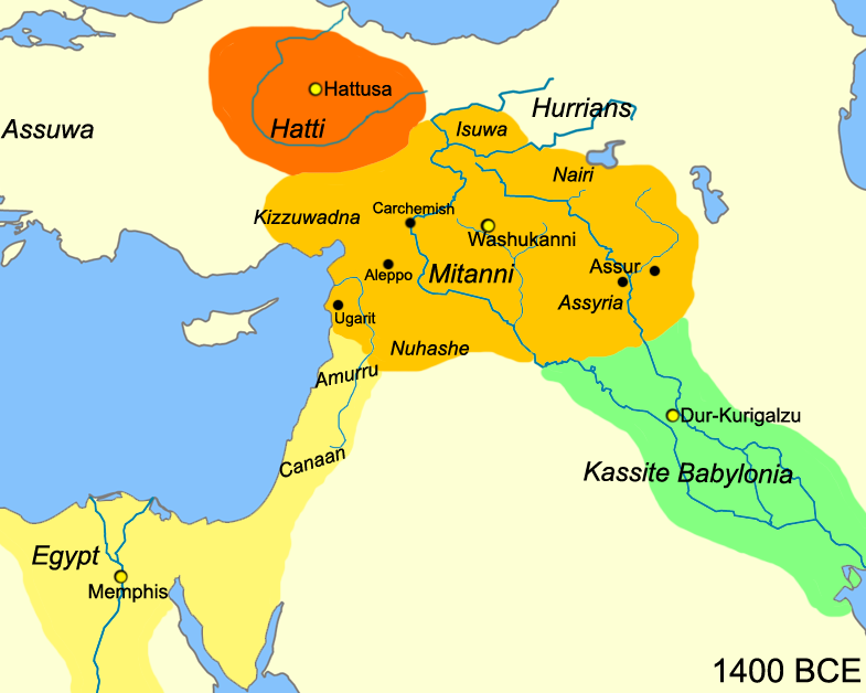
Mitanni Lands. Source: Wikipedia
The kingdom of the Mitanni Indo-Iranian dynasty that ruled in the land of the Hurrians was located in the upper Euphrates-Tigris basin - land that is now part of northern Iraq, Syria and south-eastern Turkey.

At its greatest extent (for a brief period at the height of its dynastic power), Mitanni territory extended to the Mediterranean coast and into northern Assyria / Mesopotamia, it's south-eastern neighbour.

Mitanni's north-western border with the Hattian kingdom of the Hittites was fluid and constantly subject to aggression except when the two rivals concluded a peace treaty - one that invoked the Indo-Iranian pantheon of Mitra, Varuna, Indra and the Nasatyas - but also one that marked the decline of the Mitanni kingdom and a decrease in size. The Mitanni and Hittites were closely related. The Hittites used the Hurrian language extensively in their inscriptions. They also shared in the development of the light chariot whose wheels used spokes (see below).

The Hurrian lands are today a part of Greater Kurdistan.


__________________


Guru

Status: Offline
Posts: 24601
Date:
Permalink  
 

Wassukanni / Washukanni - Mitanni Capital

Reputed location of Washukanni: Tell Fecheriye, Syria. Source: Wikipedia
Reputed location of the Mitanni capital, Washukanni: Tell Fecheriye, Syria. Source: Wikipedia
The Mitanni capital was Wassukanni / Washukanniand its location has been determined by archaeologists to be on the headwaters of the River Habur, a tributary of the Euphrates.

The name Washukanni is similar to the Kurdish word bashkanibashmeaning good and kanîmeaning well or source (Kurdish has the same name, kani, for well and source). The Luwian word vasu also means good. The name is similar to the Sanskrit word vasukhani meaning 'mine of wealth'.

Some believe the ancient city of Sikan was built on the site of Washukanni, and that its ruins may be located under the mound of Tell Fecheriye/el Fakhariya near Gozan in Syria. Other proposed locations for Wassukanni are Rais el Ain in Syria (80 km. east of Akcakale, Turkey), and further north near Diyarbakir (ancient Amida), a Kurdish city and province.


The Mitanni Dynasty

The Mitanni dynasty ruled over the northern Euphrates-Tigris region between c. 1475 and c. 1275 BCE. While the Mitanni kings were Indo-Iranians, they used the language of the local people which was at that time a non Indo-Iranian language, Hurrian.


Tushratta's letter to Amenhotep III of Egypt. British Museum WAA 29791
Tushratta's letter to Amenhotep III of Egypt Amarna
from Tell el-Amarna. Housed at British Museum WAA 29791
For a period, the extent of Mitanni control included parts of northern Assyria, including the Nineveh and Ashur. However, after the mid-fourteenth century BCE, Mitanni was plagued by a dynastic crisis and palace intrigue. It appears that the young king Tusratta who had been installed as a figure-head after the murder of his father, was not universally recognized and as a result, he lost control of the Assyrian lands at the outset of his reign. At the same time, in northeast Mitanni, a rival named Artatama II seems to have created a kingdom of his own and the Hittites invaded Mitanni - an attack that Tusratta managed to repulse.

Despite Tusratta's problems, he was not beyond offering his daughter Tadukhipa in marriage to the King Amenhotep III of Egypt for a large quantity of gold. The tablet seen to the right is a letter from Tusratta to Amenhotep in which he asks for "gold in very great quantity" as a bride price, supporting his request with the comment, "Gold is as dust in the land of my brother."

The beleaguered Tusratta was then murdered by his son in a palace coup. Tusratta's other son, Prince Shattiwaza, fled Mitanni and was eventually given sanctuary by the Hittite King Suppiluliuma with whom he concluded a treaty c. 1380 BCE, which we know as the Suppiluliuma-Shattiwaza Treaty (discovered in 1907 CE in Hattusa, near present-day Bogazkale (Boğazkale, formerly Bogazköy) in north-central Turkey. In the treaty, the Hittite King Suppiluliuma agreed to assist Shattiwaza gain the Mitanni throne and invaded Mitanni. The Hittites captured the Mitanni capital Wassukanni after a second attempt and installed Shattiwaza as a vassal king.

The Suppiluliuma-Shattiwaza Treaty is a source of considerable information about the Mitanni. In addition, it gives us some astonishing information about the religious practices of the Mitanni for it invokes the Indo-Iranian pantheon of asuras and devas Mitras(il) (Mitra)Uruvanass(il) (Varuna)Indara (Indra) and the Nasatianna (Nasatyas) (Ashwins).

Following the capture of Wassukanni, the Hittites installed new rulers in Mitanni towns while the Assyrians regained control of the territory they had lost to the Mitanni. Tusratta was killed and his son Shattiwaza became a vassal of the Hittite Suppiluliuma (c.1344 - 1322 BCE). At the same time, the rebellious Artatama became a puppet king of a reborn Assyria, led by king Assur-Uballit I (1364-1328 BCE). Wassukanni was sacked again by the Assyrian king Adad-Nirari I around 1290 BCE, after which very little is known of its history.

In our page on the Hittites, we note:
"In the Bogazkale archives, native Hurrian is used frequently for a wide range of non-official texts such as those on rituals and even the Epic of Gilgamesh - more so than native Hattian. Native Hurrian texts have been found throughout the region. One such text dated to 1750 BCE was found at Tell Hariri (ancient Mari), a Middle Euphrates site, and another at Ras Shamra (Ugarit) on the Syrian coast indicating Hurrian i.e. Mitanni influence in the region preceded the rise of Hittite power. A similar language to Hurrian is the language of Urartu located to the east of the Hittite lands at the headwaters of the Euphrates and around Lake Van. According to the literature (cf. The Hittites by O. R. Gurney, Penguin Books 1981), The Hurrians were migrants to the Upper Euphrates and Habur basin from the Elburz Mountains east across the Taurus Mountains from about 2300 BCE onwards."


Famed Charioteers

Map of the Kurdish speaking areas of the Middle East and Anatolia
Mitanni Chariot
note wheels with spokes
The Mitanni were famed charioteers. They are reported to have spearheaded the development of the light war chariot with wheels that used spokes rather than solid wood wheels like those used by the Sumerians.

The Mitanni name for chariot warriors was maryanna or marijannina, a form of the Indo-Iranian term marya meaning 'young man," used in the Rig Veda when referring to the celestial warriors assembled around the Vedic deity Indra.


Expertise in Horse Training

The Hittite archives of Hattusa, near present-day Bogazkale contained what is the oldest surviving horse training manual in the world. The elaborate work was written c. 1345 BCE on four tablets and contains 1080 lines by a Mitanni horse trainer named Kikkuli. It begins with the words, "Thus speaks Kikkuli, master horse trainer of the land of Mitanni" and uses various Indo-Iranian words for horse colours, numbers and names. Examples are:
  assussanni a form of the Sanskrit asva-sani meaning 'horse trainer',
  aika wartanna meaning one turn (cf. Vedic Sanskrit ek vartanam),
  tera wartanna meaning three turns (cf. Vedic Sanskrit tri vartanam),
  panza wartanna meaning five turns (cf. Vedic Sanskrit panca vartanam),
  satta wartanna meaning seven turns (cf. Vedic Sanskrit sapta vartanam), and
  navartanna meaning nine turns (cf. Vedic Sanskrit nava vartanam).
[Regrettably, writers do not mention the Old Iranian equivalents.]

A Hurrian text from Yorgan Tepe also uses Indo-Iranian words to describe the colour of horses, words such as babru for brown, parita for grey, and pinkara for a reddish hue.

The Kikkuli manual for training chariot horses highlights the links between the Mitanni and Hittites. Even though they were rivals at times, the two groups also collaborated frequently. The fact that the Hittites employed a Mitanni as a master trainer of horses may indicate that it was the Mitanni who were the regional experts in horse training especially for military purposes (in a manner similar to the Sogdians in the East) and that the Mitanni in turn had brought the expertise with them in their migration westward.

The methods used in the Kikkuli method enabled horses to be trained without injury. The text detailed a 214-day training regime using interval training and sports medicine techniques such as the principle of progression, peak loading systems, electrolyte replacement, fartlek training, intervals and repetitions and was directed at horses with a high proportion of slow-twitch muscle fibres. the Kikkuli horses were stabled, rugged, washed down with warm water and fed oats, barley and hay at least three times per day.

Kikkuli's interval training technique stressed the leading of horses at a trot, canter and gallop, before subjecting them to the weight bearing stress of a rider, driver or chariot. Workouts sometimes numbered three a day with scheduled rest days. Kikkuli's interval training contained three stages - the first two for developing strong legs and a strong cardio-muscular system, and the third for increasing neuromuscular conditioning. His workouts included brief recoveries to lower the heart rate. Swimming was also included in intervals of three to five sessions, with rest periods after each session. The horses were also subject to warming down periods and the method's example of cantering included intermediate pauses to lower the heart rate partially and as the training advanced the workouts included intervals at the canter.


Mitanni Indo-Iranian Names

The names of the Mitanni kings and their capital city were of Indo-Iranian origin. For instance, Tueratta was a form of the Indo-Iranian Tvesa-ratha meaning 'Possessor of a Chariot'. The name S'attuara was a form of Satvar meaning 'warrior' and the name of the Mitanni capital Wassukanni, was a form of Vasu-khani meaning 'wealth-mine'.

The names of proto-Indo-Iranian dieties are also found to form the names of the Kassite rulers of Babylonia.


__________________


Guru

Status: Offline
Posts: 24601
Date:
Permalink  
 

Arta

Several Mitanni names contained the Old Persian term arta, a derivative of asha via arsha, meaning cosmic order and truth (arta transforms to the Sanskrit r'ta). Arta is found used in Old Persian Achaemenian names (e.g. Artakhshassa c.450 BCE) and in the Sogdian Avesta as well. Asha is the central ethical concept of the Avesta.

Philologists trace the Mitanni names to the Vedic equivalents. For instance, they note that the royal name Artatama was a form of the Indo-Iranian R'ta-dhaanman meaning 'the abode of rta', and the name Artas's'umara was a form of Rta-smara meaning 'remembering r'ta'.

However, for some reason, none of the writers that we have come across link the name to their Old Iranian or Old Persian equivalents - equivalents that will be closer to the Mitanni names as we have demonstrated with the use of arta above.


Society Structure & Rule of Law

Mitanni society was structured into classes, ranks, and professions, in a manner similar to the Jamshidi system of professional guilds. The judiciary was well organized and the records display a strong emphasis on correct procedure.


Land Conveyance

The aristocratic families usually received their landed property as an inalienable fief, in other words, The land grant included a provision that the land could only be transferred to children of the owner - it could not be sold. Nevertheless, sellers and buyers found a convenient work-around and the prohibition against selling landed property was circumvented by the owner of property 'adopting' the buyer for an acceptable sum of money. The wealthy landlord Tehiptilla was 'adopted' almost two hundred times, acquiring tremendous holdings of landed property in this way without interference by the local governmental authorities.


Agriculture & Manufacturing

The system of planting crops included a productive two-field system of agriculture in which an agricultural plot was divided into two fields where each field was cultivated only once every two years.

Records indicate that sheep were bred for their wool on which an extensive woollen and textile industry was based. The manufactured textiles were collected by the palace were exported on a large scale.

According to the Metropolitan Museum of Art, "glass was produced on a large scale for the first time around 1600 BCE, perhaps in the Mitanni state of northern Mesopotamia."


Trade

Trade in the Euphrates-Tigris basin was conducted using the extensive river network and the Mitanni controlled the river trade routes down the River Habur to Mari and from there up the River Euphrates to Carchemish. They also controlled trade along the upper Tigris River and its headwaters at Nineveh, Arbil, Ashur and Nuzi. 


__________________


Guru

Status: Offline
Posts: 24601
Date:
Permalink  
 

Hittite Sun Disk. Image at Flickr by voyageAnatolia.blogspot.com


__________________


Guru

Status: Offline
Posts: 24601
Date:
Permalink  
 

Hittite's Aryan Connections

The Hittites were the people who ruled the central Anatolian kingdom of Hatti from c. 1900 - 800 BCE. They formed the earliest known Anatolian civilization and employed an advanced system of government based on an established legal system. Their military was well trained, well equipped, and employed chariots that were the lightest and fastest of their time.

Together with their southern neighbours, the Mitanni, the Hittites acknowledged Aryan (Indo-Iranian) deities such as Mitra, Varuna, Indra and used names with Aryan roots. Both appear on the historical stage in the Upper Euphrates basin, the Hittites to the north of the Euphrates and the Mitanni to the south. At different periods, they were allies or rivals. The land of the Hittites was called Katpatuka (Cappadocia) during Persian Achaemenian times (675 - 330 BCE). Strabo in the first century ACE, noted that the magi of Cappadocia "... have Pyraetheia (fire-houses), noteworthy enclosures...", the first record of Zoroastrian fire temples. Katpatuka / Cappadocia - the old Hittite land - could have been the western extent of Ranghaya, the sixteenth and last Aryan land in the Vendidad - the last land mentioned before the Avestan canon was closed.

While the Hittites may have been immigrants to the land of Hatti, they peacefully adapted to the language, custom and religion of the aboriginal Hattians with whom they enjoyed a mutually profitable and amicable relationship. They brought with them various technologies including Metal Age manufacturing methods such as the smelting and casting of iron.


History

Hittites first appear in the historical stage (though we use the word 'first' cautiously as this relates only to archaeological evidence) as rulers of the city of Kussara in south-eastern Anatolia somewhere between Nesa (Central Turkey today, see map below) and Aleppo (Northern Syria). The earliest known member of a Hittite speaking dynasty, Pithana, was based in Kussara. Pithana conquered the town of Nesa (or Nesha), near present-day Kayseri in central Turkey, and the city which the Hittites considered their city of origin. Shortly after 1800 BCE Pithana's son Anitta extended these conquests, capturing Hattusa, near present-day Bogazkale (Boğazkale, formerly Bogazköy) in north-central Turkey. Under subsequent kings of the Old Kingdom, Hattusa would become the future Hittite capital. Anitta, left records indicating his achievements, but he does not appear to have created an empire or to have founded a dynasty. The period after him was characterized by power struggles.


Map of Anatolia / Asia Minor. Hittite Hatti occupied land in the centre of this map. Base image courtesy Microsoft Encarta
Site Map of Anatolia / Asia Minor. the Hittite Hatti heartland occupied land in the centre of this map. Base image courtesy Microsoft Encarta
It was the Hittite king Labarna, or Tabarna, (r. 1680-1650 BCE) who established what some call the Old Kingdom (c. 1680 - 1400 BCE), and from the time of its establishment, the Hittite kingdom rapidly grew in size. The establishment of the kingdom and the dynasty are chronicled in the Proclamation of Telepenus (c. 1525-1500 BCE). The Proclamation states that King Labarna consolidated power among the disparate Hittite city states and then proceeded to conquer nearly all of central Anatolia up to its shores. His successor Labarna II also known as Hattusili I (c. 1650-1620 BCE) continued to consolidate the kingdom as well as a dynastic line. Hattusilis' (adopted son or grandson?) successor, Mursili I (r. 1620-1590 BCE), further extended Hittite rule by conquering Aleppo (what is Halab today) in Assyria, and then went on to raid, but not rule, Babylon c.1595 BCE.

The consolidation and expansion of the Hittite kingdom into an empire (sometimes known as the New Kingdom or Empire c. 1400 - 1180 BCE) took place during the reign of Prince Suppiluliuma (r. c.1380-1346 BCE), a reputed usurper of the Hittite throne. Suppiluliuma rebuilt the capital at Hattusa and reorganized the government. He built on his military successes by defeating the Mitanni King Tusratta with whom his relations had become advesarial. In Tusratta's place, he installed his Mitanni ally Prince Shattiwaza, who had fled Mitanni and sought sanctuary in Hatti. The two kings concluded a treaty c. 1380 BCE, which we know as the Suppiluliuma-Shattiwaza Treaty, the result of which gave Suppiluliuma control over various Mitanni vassal states including parts of Assyria. With his acquisition of Assyrian lands, Hattusa's empire now rivalled the power of Egypt under pharaoh Amenhotep IV, or Akhenaton, as well as that of Babylonia and Assyria. During the 15th and 14th centuries BCE, subsequent Hittite kings extended the extent of their empire westward to the Aegean Sea, eastward into Armenia, south-eastward into upper Mesopotamia, and southward as far as the mouth of the Litani River (a territory known as Amqu) in present-day Lebanon.


__________________


Guru

Status: Offline
Posts: 24601
Date:
Permalink  
 

The Hittite king Hattusili III (r. 1289-1265 BCE) concluded a treaty of peace and alliance with Egyptian Pharaoh Ramses and gave Ramses his daughter in marriage. In c.1200 BCE the Hittite Empire fell to invaders called the Sea Peoples in Egyptian records, and shrank to collection of Neo-Hittite city states such as Carchemish and Milid (present-day Malatya).


Sources of Information

Information about the Hittites comes from a 1906 discovery of the Hittite's royal archives during excavations at Boğazkale. Another source is Egyptian records. The Hittites may also be mentioned in the Jewish scriptures as the sons of Heth, but this theory is disputed.


Hittite Languages

The royal Hittite archives at Bogazkale contain over 10,000 tablets whose cuneiform inscriptions are written in eight different languages:
1. Hittite (most of the texts were written in the Hittite language which the authors called Nesili (or Kanesili). The earliest examples of Nesili were found in the Hittite settlement of Nesa, also known as Kanesh (near Kültepe and about 20 km southwest of modern Kayseri) in the record of trade between Assyrian merchants and the 'land of Hatti'),
4. Native Hattian (the native language of the Hittite lands, Hatti, and a language completely different from Hittite. It was used for religious texts only),
2. Mitanni,
3. Native Hurrian (the native language of neighbouring Mitanni. Significantly, the Hurrian language was used for non-official texts to a far greater extent than native Hattian, Luwian or Palaic, leaving the impression that native Hattian was used only for religious purposes in the same manner Sanskrit and Avestan are used today),
5. Akkadian (the international language of the region that was used for treaties and state letters),
6. Luwian (also spelt Luvian - a language closely related to Hittite and spoken in Arzawa and Kizzuwatna to the southwest of Hatti - an area called Luwia and later Lydia. By the end of the Hittite Empire, the population of most of the Hittite Empire spoke Luwian dialects),
7. Palaic (Palaumnili - language of the people of Pala who appear to have lived to the west of the Hittite core area between modern Kayseri and Sivas), and
8. Sumerian.

The use of eight different languages spoken throughout the region is significant and indicate the intended readership of both local and international visitors to the Hittite capital. Of the eight languages, for their official documents, the Hittite kings used only the Nesili Hittite and Akkadian.

In multi-lingual texts found in Hittite locations, passages written in the Hittite language are preceded by the phrase "in Nesumnili ( i.e. language of the people of Neša, otherwise called Nesili, Nasili or Nisili)". In one case, the label is "in Kanisumnili (i.e. language of the people of Kanesh)". The religious native Hattian texts are introduced with the phrase "in Hatilli (i.e. language of the people of Hatti).

In the Boğazkale archives, native Hurrian is used frequently for a wide range of non-official texts such as those on rituals and even the Epic of Gilgamesh - more so than native Hattian. Native Hurrian texts have been found throughout the region. One such text dated to 1750 BCE was found at Tell Hariri (ancient Mari), a Middle Euphrates site, and another at Ras Shamra (Ugarit) on the Syrian coast indicating Hurrian i.e. Mitanni influence in the region preceded the rise of Hittite power under Suppiluliuma. A similar language to Hurrian is the language of Urartu located to the east of the Hittite lands at the headwaters of the Euphrates and around Lake Van. According to the literature (cf. The Hittites by O. R. Gurney, Penguin Books 1981), The Hurrians were migrants to the Upper Euphrates and Habur basin from the Elburz Mountains east across the Taurus Mountains from about 2300 BCE onwards.

For a script, the Hittites used the cuneiform system and hieroglyphs. The cuneiform Hittites texts were written on clay tablets that were discovered during excavations at the end of the 19th century CE. Identification of the language had to wait until 1915 when Czech linguist Bedřich Hrozný, after examining tablets that had been brought to Vienna from the Istanbul Museum, identified the language of the Hittite tablets as Indo-European. He published his findings in a 1917 book titled Die Sprache der Hethiter. In 1951 a comprehensive Hittite grammar was presented in a book titled A Comparative Grammar of the Hittite Language by Edgar H. Sturtevant.

As evidenced by the records discovered, the Hittites had a highly developed literature consisting of stories, religious texts, historical records, legal system and legal documents.

On line pages on Hittite grammar and language:
» Hittite Language Lesson at University of Texas
» The Hittite Grammar Homepage


__________________


Guru

Status: Offline
Posts: 24601
Date:
Permalink  


Governance

In the Hittite system of governance, the Hittite king acted as the supreme priest, military commander, and chief judge of the land. In the early years of the empire, the king was assisted by the pankus, an advisory council of nobles. The different provinces of the empire were administered by provincial governors. Certain states at the edge of the empires were ruled by vassal kings under terms of a formal treaty.

In their legal code, the Hittites rarely resorted to the death penalty or to bodily mutilation as punishment for breaking the law - penalties that were frequently used by other ancient Middle Eastern kingdoms. Rather than relying on retribution or vengeance, the principle for redressing transgressions was restitution. For instance, the penalty for theft was restoration of the stolen property and payment of an additional recompense. In due course, restitution in kind was gradually replaced by payment of money.

Economy

The Hittite economy was based on agriculture, trade and manufacture. The mineral resources that they processed were copper, lead, silver, and iron. Their metallurgical techniques were advanced for the time and parallel the metallurgical advances by Indo-Iranians in Central Asia.

Hittite weapons were made from bronze. Iron was so rare and precious that it was employed only for the manufacture of prestigious goods. Correspondence with other governments indicate international demand for Hittite iron goods. The evidence of iron tool production dates back at least as far as the 20th century BCE.

One example of Hittite technology skills is their skill in building and using chariots.

Hattusa - Hittite Capital (near Bogazkale)

Satellite view of the ruins of the Hittite capital Hattusa next to the modern town of Bogazkale. Base image courtesy Google Earth

Click to view Larger Map
Interactive satellite image of Hattusa / Bogazkale from Google Maps. Zoom in to see a close-up of the structures
Aerial view of Lower Hattusa looking south. The town of Bogazköy is to the right (west)
Aerial view of Lower Hattusa (a) looking south. Upper Hattusa is in the background.
Bogazkale (Bogazköy) town is to right (west). Image at hattuscha.de
Aerial view of Upper Hattusa looking east. Bogazköy is to the left (north)
Aerial view of Upper Hattusa looking east. Bogazkale (Bogazköy) is to the left (north). Image at hattuscha.de
The ruins of the ancient Hittite city of Hattusa (known as Hattus in Hattic), capital of the Old Hittite Kingdom, can be found next to the village of Bogazkale (formerly Bogazköy), in Çorum Province and some 87 km. southwest of the city of Çorum. Bogazkale (Bogazköy) is located at the southern end of the Budaközü River valley, at an elevation of 300 metres, and where the northern plains enter a valley surrounded by rock outcrops.

Evidence of a settlement at Hattusa predates Hittite presence by thousands of years goes back to the sixth millennium BCE, when it was inhabited by the native Hatti people. The Hittite's initial capture of the city was destructive. A carbonized layer in the excavations that is dated at c. 1700 BCE, indicates a burning of the city - a burning credited to the Hittite king King Anitta who was then based in southern city of Kushar. After destroying the city, Anitta left behind an inscription stating, "At night I took the city by force. I have sown weeds in its place. Should any king after me attempt to resettle Hattush (the city's name in Hittite), may the Storm God of Heaven strike him down." This inscription known as the Proclamation of Anitta is the earliest text found at Hattusa and the earliest known text composed by a Hittite king.

A subsequent Hittite king, Labarna II (c. 1650-1620 BCE) seems to have ignored Anitta's curse and returned to the site to resettle Hattusa and make it his capital. He called himself Hattusili I.

Evidence in the form of cuneiform tablets, shows that in the 19th and 18th centuries BCE, merchants (apparently from Ashur (Assur) in Assyria), established a trading post and separate living quarters in Lower Hattusa. Among the goods they traded were tin, wool, foodstuffs, spices, and woven fabrics. Assyrian trading colonies in Anatolia were called kârum and the largest known karum and the centre of Hatti's trade network was at the ancient settlement of Kanesa (or Kanesh) - commonly contracted to Nesa (or Nesha) and located near the modern village Kültepe in Kayseri Province. Kültepe is about 200 km. southeast of Hattusa.

Upper Hattusas is about a kilometer square in size and was developed during the 13th century BCE. It was surrounded by a wall with several gates. A large part of the upper city consisted of temples and ritual areas.

External links:
» Bogazkale pictures
» Hattusa by Günther Eichhorn
» German ArchaeoIogical Institute - Excavations at Hattusa
» Hattusas
 

Excavations at Hattusa, Bogazkale

After Charles Dexter examined the ruins in 1834 and evoked interest in the significance of the ruins, Sayce made the first connection between with the ruins and the Hittite state. Until then, the Hittites were thought to have been based Syria. In 1882, Carl Human and Otto Puchstein visited Bogazkale with the intention of making a comprehensive study of the site. It was not until the years 1893-1894 that Ernest Chantre dug some explorative trenches.

In 1905-06 excavations of Hattusa were conducted under the supervision of Hugo Winckler and Theodor Makridi, members of Deutsche Orientgesellschaft (the German Oriental Society). These two archaeologists were joined in the following year by Otto Puchstein, and their work continued until 1912. After a hiatus due to the First World War, excavations were resumed in 1931 under the direction of Kurt Bittel - excavations that were again interrupted and resumed after the Second World War.

In 1917, the German excavators removed a sphinx from Hattusa and sent it to Germany. The Turkish Government has been unsuccessful in seeking its return and the sphinx remains on display in Berlin's Pergamon Museum.

Hoyuk or tepe - a mound on a plain caused by soil covering a buried site
Hoyuk or tepe - a mound on a plain
caused by soil covering a buried site.
Also called a tel in archaeology. Image at Anatolia

Sakje-Geuzi

Excavations conducted at the undisturbed tepe at Sakje-Geuzi revealed evidence of a continuous culture which began to flourish before 3000 BCE. Discovered buried in a lower layer were Neolithic Age yellow-painted pottery with black geometric designs. The painted design on the pottery resembles the design on painted fabrics found in Turkestan by the Pumpelly expedition, as well as the design on artefacts found at great distances from one another - at sites in Susa and its vicinity by De Morgan, in the Balkan peninsula by Schliemann, in a First Dynasty tomb at Abydos in Egypt by Petrie, and in the late Neolithic and early Bronze Age (Minoan) strata of Crete by Evans.

The similarity in design could be more than coincidental and could be the result of trade and other connections between nations from Egypt to Central Asia - nations that were on the Aryan trade roads.

External links:
» Hittite/Hurrian Mythology


http://www.heritageinstitute.com/zoroastrianism/ranghaya/hittites.htm

Farohar-like Kassite symbol
spacer

Contents

Kassites

Kassite Dynasty

Kassites (from the Akkadian Kassu) is the name given to the dynasty that ruled Babylonia from the 16th to 12th centuries BCE, and to the 5th to 1st century BCE Kossaean / Cossaean (from Gk. Kossaioii) nation that was located in the Hamadan-Kermanshah-Luristan area in present day Iran. We know about the Babylonian Kassites from inscriptions and tablets found in the region, and we read mention of the Kossaeans in the writings of several classical Greek writers.

Map of Anatolia. Base image courtesy Microsoft Encarta
Several modern historians such as K. Balkan (in 1986, p. 8) and M. Heinz (in 1995, p. 167) have stated that the Kassite rulers of Babylon were members of the Indo-Iranian Kossaean people based in Hamadan-Kermanshah-Luristan area, but whose origins are not mentioned in historical records. The historians make several additional conclusions or assumptions:

First, that the Kossaeans mentioned by Greek writers were the successors of the Babylonian Kassites who were driven out of Babylonia by conquering Elamites (neighbours of the Kossaeans) in the 12th century BCE.

Second, that the Kassites in fleeing to Kossaea were returning to their ancestral lands.

Third, that the Kassites were originally Indo-Iranian Kossaeans who had settled the Hamadan-Kermanshah-Luristan area prior to the 17th century BCE.

Fourth, that the Indo-Iranian Kossaeans were immigrants to the area since they are not mentioned as being among the peoples who inhabited the central and southern Zagros in Sargonic (2270-2215 BCE) and Ur III / Third Dynasty of Ur era (21st to 20th century BCE) inscriptions. As we shall see below, these assumptions and conclusions are plausible.

Hamadan and Kermanshah, are two provinces with eponymous capital cities that straddle the northern Zagros mountains placing them strategically on the Aryan trade roads - the Silk Roads. Luristan lies to their south and the Iranian province of Elam is found to the west of Luristan. Elam and Kermanshah border modern-day Iraq and what would have been Northern Babylonia (see map).

Babylonian/Kassite Chronology & References

The chronology of events in Babylonia in particular and the Middle East in general during the 3rd and 2nd millennia BCE is not precise and can be quite confusing when reading the literature. There are four different ancient Middle East chronologies called Ultra-Low, Short or Low, Middle, and Long or High.

For the time period when the Kassites ruled Babylonia, the Middle to Late Bronze Age, the chronologies are determined by the date of the sacking of Babylon by the Hittites. The short chronology which places the sack of Babylon at 1531 BCE is currently the most widely accepted (and used in this page) while older literatures favours the middle chronology which places the sack of Babylon at 1595 BCE.

The following table gives an overview of the different chronologies, listing some key dates and deviation relative to the short chronology (source Wikipedia):

ChronologyAmmisaduqa Year 8Reign of HammurabiSack of Babylon±
Ultra-Low1542 BCE1696 BCE - 1654 BCE1499 BCE+32 years
Short or Low1574 BCE1728 BCE - 1686 BCE1531 BCE±0 years
Middle1638 BCE1792 BCE - 1750 BCE1595 BCE-64 years
Long or High1694 BCE1848 BCE - 1806 BCE1651 BCE-120 years

Kassites - Babylonian Rulers (16th - 12th Centuries BCE)

1770 BCE: The earliest written record of an individual with a Kassite name in Babylonia region is from a 1770 BCE inscription made by Sumerian city-state Larsa ruler Rim-Sin I (1758-1699 BCE). Larsa was located south of Babylon near Uruk.

1742 BCE: The Kassites as a political force entered written history with the record of their attack on Babylonia in 1742 or 1741 BCE - an attack that was repelled by the Babylonians. At that time, the king of Babylonia was Samsu-Iluna (also Samsiluna. reign c. 1749 - 1712 BCE), son of Hammurabi. [Sassmannshausen (1999, pp. 411 f.) is of the opinion that they penetrated from the central Zagros via the lower Diyala region into northern Babylonia, notably the Sippar region during the late Old Babylonian period.] Thereafter, Kassite groups and individuals are found recorded in northern Babylonian texts, especially in inscriptions found in the area around Sippar Yahrurum (see Zadok, 1987, pp. 17 ff.; De Smet, 1990; De Graef, 1998, pp. 5 ff.; Pientka, 1998, pp. 257 ff.; Sassmannshausen, 2000, pp. 415 f.).

1531 BCE: While the initial Kassite attack was not successful, later, sometime after Babylon succumbed to the Hittite invasion in c. 1531 BCE called the 'sack of Babylon' (the Hittites did not occupy Babylon after their plundering raid), the Kassites under the command of Agum-Kak-Reme gained control of northern Babylonia.

1475 BCE: In c. 1475-1450 BCE, the Kassites (under King Ulamburiash?) went on to conquer southern Babylonia.

Dur Kurigalzu Citadel at modern Aqar-Quf west of Baghdad, Iraq
1400-1225 BCE: After consolidating their rule over Babylonia, the Kassites under Kurigalzu I (c. 1400-1375 BCE) built a new capital, Dur Kurigalzu, modern Aqar-Quf west of Baghdad, Iraq, while giving the name Karanduniashto the city of Babylon. After Kurigalzu II (c. 1332-1308 BCE) was defeated in a war with the Assyrians, his successors allied themselves with the Hittites in order to defend against Assyrian expansion. During the reign of Kashtiliash IV (c. 1232-1225 BCE), Babylonia fought two simultaneous and disastrous wars against Elam and Assyria culminating in the invasion and destruction of Babylon by Tukulti-Ninurta I.

1216-1155 BCE: Kassite Babylonia would have to wait until the time of kings Adad-shum-usur (c. 1216-1187 BCE) and Melishipak (c. 1186-1172 BCE) to experience a period of relative peace. Their successors were obliged to defend Babylonia once again this time against an assault from the Elamite king Shutruk-Nahhunte (c. 1185-1155 BCE) who led a cruel and fierce army that defeated and brought to an end the Kassite dynasty around 1155 BCE. The last Kassite king, Enlil-nadin-ahi, was imprisoned in Susa where he died.

Once the Kassites had established themselves in Babylonia, they had no further expansionist plans and sought to bring order, peace and prosperity to Babylonia. The Kassite kings ruled a unified Babylonia for almost four hundred years - longer than any other dynasty in Babylonian history. Under them, Babylon achieved a relative stability that enabled it to become the political and cultural center of the ancient world.

Post-Babylonian Kassites - Kossaeans/Cossaeans

After their expulsion from Babylon, the Kassites next reappear in an inscription recording the attack by Sennacherib in 702 BCE of the Khabira clan living in the Zagros mountains northwest of Elam, immediately south of Holwan.

A few hundred years later, a nation of Kissia / Cissia the same area of the Zagros mountains are mentioned by Aeschylus (c. 525-456 BCE) in his Choephori line 424, Persians lines 17, 120, and Herodotus (c. 484-425 BCE) in Histories Book 5. sections 49, 52.

Five hundred years later, the Kissians / Cissians of Herodotus and Aeschylus appear to have become Kossaeans / Cossaeans in Greek literature. Strabo (63/64 BCE - 24 CE) writes (xi. 13,3,6) that a people called Kossaeans or Cossaeans were the neighbours of the Medes and that Alexander the Macedonian battled Kossaeans in the winter of 323 BCE on his way from Ecbatana to Babylon. The campaign was extremely bloody, and Alexander's contemporaries thought that Alexander was in a rage venting his emotions because his lover Hephaestion had died. Next we read mention of Susiana being divided between Kossaeans and the Elymaeans (Elamites) in the writings of Ptolemy (90-168 CE).

The quotes from translations of these texts are reproduced below:

Herodotus (c. 484-425 BCE)
5.49 "Next to the Phrygians are the Cappadokians, whom we call Syrians; and bordering upon them are the Kilikians, coming down to this sea, in which lies the island of Cyprus here; and these pay five hundred talents to the king for their yearly tribute. Next to these Kilikians are the Armenians, who you may see here and these also have great numbers of sheep and cattle. Next to the Armenians are the Matienians occupying this country here; and next to them is the land of Kissia here, in which land by the banks of this river Choaspes is situated that city of Susa where the great king has his residence, and where the money is laid up in treasuries"

5.52 "As regards this road (Royal Road of Darius) the truth is as follows: Everywhere there are royal stages [and excellent resting-places], and the whole road runs through country which is inhabited and safe. ...Passing thence into the Kissian land, there are eleven stages, forty-two and a half leagues, to the river Choaspes, which is also a navigable stream; and upon this is built the city of Susa."

Diodorus Siculus (Works dated to 60 and 30 BCE i.e. 1st century BCE)
Book XVII, Section 111. 4 "...Alexander launched a campaign (324/3 BCE) with a mobile force against the Cossaeans, for they would not submit to him. This is a people outstanding in valour which occupied the mountains of Media; and relying upon the ruggedness of their country and their ability in war, they had never accepted a foreign master, but had remained unconquered throughout the whole period of the Persian kingdom, and now they were too proudly self-confident to be terrified of the Macedonian arms. 5 The king, nevertheless, seized the routes of access into their country before they were aware of it, lay waste most of Cossaea, was superior in every engagement, and both slew many of the Cossaeans and captured many times more. So the Cossaeans were utterly defeated, and, distressed at the number of their captives, were constrained to buy their recovery at the price of national submission. 6 They placed themselves in Alexander's hands and were granted peace on condition that they should do his bidding. In forty days at most, he had conquered this people. He founded strong cities at strategic points and rested his army."

[Note: The above is an example of Alexander's gratuitous brutality recorded in the Greek texts. Another example was when he wanted to test the validity of claims regarding the inflammability of naphtha. Strabo (63/64 BCE - 24 ACE) in Geography, Book XVI, Chapter 1.15 writes: "...naphtha, is of a singular nature; for it the naphtha is brought near fire it catches the fire; and if you smear a body with it and bring it near to the fire, the body bursts into flames; and it is impossible to quench these flames with water (for they burn more violently), unless a great amount is used, though they can be smothered and quenched with mud, vinegar, alum, and bird-lime. It is said that Alexander, for an experiment, poured some naphtha on a boy in a bath and brought a lamp near him; and that the boy, enveloped in flames, would have been nearly burned to death if the bystanders had not, by pouring on him a very great quantity of water, prevailed over the fire and saved his life."]

Strabo (63/64 BCE - 24 ACE):
Geography, Book XVI, Chapter 1.17. "...bordering on this country (Persis) are Paraetacenê and Cossaea as far as the Caspian Gates, which is inhabited by mountainous and predatory tribes. And bordering on Susis is Elymaïs, most of which is rugged and inhabited by brigands; and bordering Elymaïs are Media and the region of the Zagrus.

18. "Now the Cossaeans, like the neighbouring mountaineers, are for the most part bowmen, and are always out of foraging expeditions; for they have a country that is small and barren, so that they must needs live at the expense of the other tribes. And they are of necessity a powerful people, for they are all fighters; at any rate, thirteen thousand Cossaeans joined the Elymaeans in battle, when the latter were warring against both the Babylonians and the Susians."

Plutarch (46-120 CE)
Alexander, 72. "When he (Alexander) came to Ecbatana in Media and had transacted the business that was urgent, he was once more much occupied with theatres and festivals, since three thousand artists had come to him from Greece. 2 But during this time it chanced that Hephaestion had a fever... he sat down to breakfast, ate a boiled fowl, drank a huge cooler of wine, fell sick, and in a little while died. 3 Alexander's grief at this loss knew no bounds. He immediately ordered that the manes and tails of all horses and mules should be shorn in token of mourning, and took away the battlements of the cities round about; he also crucified the wretched physician, and put a stop to the sound of flutes and every kind of music in the camp for a long time, until an oracular response from Ammon came bidding him honour Hephaestion as a hero and sacrifice to him. 4 Moreover, making war a solace for his grief, he went forth to hunt and track down men, as it were, and overwhelmed the nation of the Cossaeans, slaughtering them all from the youth upwards. This was called an offering to the shade of Hephaestion."

The Kossaeans were not entirely exterminated by the murderous Alexander. Kossaeans soldiers are recorded as having served in the Macedonian army.

In 317 BCE, the Macedonian commander Antigonus Monophthalmus is quoted as saying that he encountered Kossaeans, calling them cavemen. This is significant and brings to mind the troglodyte dwellers of Kandovan in the Urmia region not too far north of Hamadan. The history of this region is replete with refugee groups retreating to remote areas in the hills and seeking refugee, shelter and anonymity in caves.

Possible Kassite Aryan or Indo-Iranian Connections

Stele depicting 'Tree of Life' and other motifs
We do not know definitively if the Kassites were an Indo-Iranian group. However, there is a similarity in their pantheon of deities and the Indo-Aryan daeva pantheon (Bloomfield, 1904; Balkan, 1986, p. 8; Eilers, 1957-58, p. 136 ad surya-) and they exhibited various Aryan traits as well. This combination of traits could have made them acceptable to the people they governed, allowing them to rule with the consent of the ruled. The Aryan traits were as follows:

Outward Cultural Integration

The Kassites were a small minority - a ruling class - amongst the Babylonians over whom they ruled. However, rather than imposing their culture - their religion, customs and language over the people over whom they ruled, they adopted many outward Babylonia customs and names, a tradition followed by other Aryans rulers in the lands they occupied (cf. Herodotus "There is no nation which so readily adopts foreign customs as the Persians"). According to A. Leo Oppenheim of University of Chicago and author of works such as Ancient Mesopotamia: portrait of a dead civilization, University of Chicago Press, 1964, "Kassite rulers in Babylon were also scrupulous to follow existing forms of expression, and the public and private patterns of behavior". The Aryan tradition was to readily adopted outward cultural norms, but to privately maintain their religion, language, philosophy, values and principles.

Religious Tolerance & Ecumenism

The Kassites followed an Aryan tradition of honouring the religious beliefs and practices of the peoples whose land they occupied or ruled. For instance, when the Hittites plundered Babylonia and carried off the idol of the Babylonian god Marduk, the Kassite king Agum II, regained possession of the idol, brought it back to Babylon, and honoured Marduk alongside the Kassite god Shuqamuna. King Cyrus of Persia would continue this tradition when he occupied Babylonia a thousand years later.

Nippur which had been left abandoned in about 1730 BCE, was rebuilt and revived by the Kassites as an important provincial center. In addition, the Kassite governor of Nippur had its dilapidated temples meticulously re-built on their old foundations, and in so doing, helped preserve the area's cultural heritage.

Trade & Economic Prosperity

The Kassites also maintained the Indo-Iranian Aryan tradition of being traders in lapis lazuli and gold (see Aryan Trade). The only known ancient source of lapis lazuli was Badakshan in present day Afghanistan and in the heart of ancient Aryan lands. The Zagros mountains had ore deposits of iron and copper which the Kassites extracted and used to manufacture vehicles such as chariots and carts. Along with horses, they exported the chariots in exchange for other raw materials. Amongst the nations with which the Kassite kings established trade and diplomatic relations were Assyria, Egypt, Elam, and the Hittite Hatti. Kassite merchants established themselves in the major cities in the region. Kassite weights and seals, the measuring and identifying and tools of commerce, have been found as far afield as Thebes (Greece), southern Armenia, and even in a shipwreck off the southern coast of Turkey.

Governance & Order

kudurru
kudurru
It would appear that in addition to their trading and manufacturing skills, one of the skills Aryans brought with them was their leadership skills and their ability to govern with order.

The system of governance employed by the Kassites was a hereditary dynasty of social-minded kings of kings - supreme kings supported by feudal or vassal kings who functioned as governors of provinces. The feudal lords were granted their land and authority by the Kassite king and the extent of land over which they had authority were recorded on stone tablets or boundary stones called kudurrus.

Deities & Names

A Kassite deity is Suriash, a name that sounds very similar to the Sanskrit Surya meaning the sun. Another Kassite deity is Maruttash which sounds similar to the Sanskrit Marut or Marutah, a Vedic storm god. A further deity is named Indas, a name that sounds similar to Indra.

Kassite royal names are thought to have elements of the names of Aryan (Indo-Iranian) deities even though the language employed by the Kassites in Babylon shows no Aryan elements.

» Kassites related images at Art History
» Babylonia Astronomy


Also see:

» Ranghaya, Sixteenth Vendidad Nation & Western Aryan Lands

» Mitanni

» Hittites

» Suppiluliuma (Hittite) - Shattiwaza (Mitanni) Treaty

» Lake Urmia & Atur-Patakan (Azerbaijan / Azarbaijan

» Kandovan (Troglodyte) Village

» Early Persian History - The Formation of Persia

http://www.heritageinstitute.com/zoroastrianism/ranghaya/kassites.htm


__________________
Page 1 of 1  sorted by
 
Quick Reply

Please log in to post quick replies.

Tweet this page Post to Digg Post to Del.icio.us


Create your own FREE Forum
Report Abuse
Powered by ActiveBoard