


A few weeks ago I gave a paper at a conference that took place at Mitzpe Ramon in the Negev Desert of southern Israel. The conference dealt with the question: which mountain in the Sinai desert, or Negev, or Saudi Arabia, is the real Mount Sinai of the Bible, where Moses received the Ten Commandments?
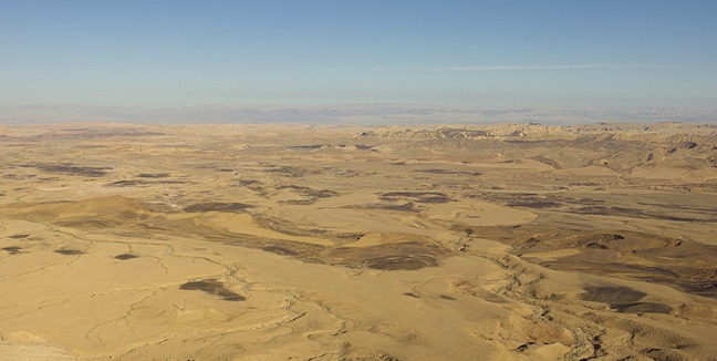
For those who have never been to Mitzpe Ramon, you’re missing out. It’s on the edge of the Ramon makhtesh – Israel’s Grand Canyon. In fact, although it is called a “crater” in English, it is actually a “makhtesh” i.e., a “box canyon”, formed not by a meteor or a river, but by geological processes of a receding ocean. It is the world’s largest “makhtesh”!
On the edge of this incredible view, a group of scholars got together to debate which mountain in the area is the real Mount Sinai. The conference (May 12-14, 2013) was sponsored by the Dead Sea and Arava Science Center under the auspices of Ben Gurion University of the Negev, the City of Mitzpe Ramon, the Negev Development Authority, the Har Hanegev Field School and the Centre for Prehistoric and Ethnologic Studies, Capo di Ponte, Italy.
Ostensibly, the gathering was asked to consider Professor Emmanuel Anati’s theory that Mount Karkom in the Negev is the real Mount Sinai. Although Mount Karkom is a very interesting location, filled with some 40,000 examples of Negev rock art, it has been clear for years that it cannot be Mount Sinai. Professor Anati deserves tremendous credit for putting Mount Karkom on the map. He has done extremely important work documenting the archaeology of this site. Also, by pushing his mountain aggressively, he has initiated conferences such as the Mitzpe Ramon gathering. But science is science and Mount Karkom is not Mount Sinai.
First of all, Mount Karkom is not even a mountain – it’s a plateau. Second of all, it conforms to almost none of the Biblical criteria (see link to my paper below). Finally, the very “proofs” that Professor Anati has pointed to have been totally refuted. For example, Professor Anati has claimed that since Mount Karkom has the largest concentration of pre-Roman rock art recorded so far in the Near East, it must be a holy site and it must be Mount Sinai. But Davida Eisenberg-Degen of the Israel Antiquity Authority demonstrated at the conference that “the quantity of petroglyphs on Mt. Karkom is average for the Central Negev”. I have no doubt that Mount Karkom – and any site where there is a high concentration of petroglyphs – was a holy site for someone but, as far as Negev holy sites go, Mount Karkom is “average”. Professor Anati claims that the pictures scratched on the rocks i.e., the content of the petroglyphs, include things like an image of the Ten Commandments. For example, he points to an image of ten boxes that he claims represent the Biblical tablets.

The Ten Commandments?
The picture is interesting, no doubt. Maybe an altar. The little arches at the top look like the corners of an altar. As tablets, they actually go against the Talmudic description of the Ten Commandments which – unlike Hollywood’s version – are supposed to be carved on square stones. Most convincingly, Professor Uzi Avner showed similar pictures containing twelve, fifteen and more boxes from the Haroz Valley, just east of Har Karkom.

Twenty Commandments?
Anati claimed to be able to date the petroglyphs to the Bronze Age period based on patina (the thin film that develops over time on rock) and content (the subject matter of the pictures). But, again, Eisenberg-Degen convincingly argued that you can’t date pictures based on the subject depicted, nor can you use patina as a reliable tool for dating ancient rock art.
This was the most interesting part of the conference. The rest of the papers were good but they seemed to be talking past each other. There was no real forum for exchanges. Everyone just kept repeating his or her old theories. For example, the venerable Professor Menashe Har-El repeated his oft stated theory that Gebel Sinn Bishr is Mount Sinai. The theory is based on the fact that at first, in the Book of Exodus, Moses asks Pharaoh to let the Israelites go three days into the desert to worship their God. Pharaoh says no, and that’s that. Based on this line, Professor Har-El says that Mount Sinai has to be a three days journey from Egypt and Sinn Bishr is a three days journey from Egypt. Professor David Faiman supports Professor Har-El and adds that since the tribe of Judah led the formation around the Ark of the Covenant, and since Judah was on the east side of the tribal formation, the Israelites always marched eastwards. This eastward march towards Canaan only works, he says, if Sinn Bishr is the mountain of God. Both these ideas do not stand up to scrutiny. Moses’ request to go three days into the desert is precisely what didn’t happen in the story of the Exodus. Pharaoh said no and it took the Biblical Israelites two weeks, not three days, to get to Mount Sinai. Furthermore, any military formation describes the beginning of a march, not every moment in it. Otherwise, you would have an Israelite army that could only march eastward and would not be able to defend itself if it was attacked from, say, the north. Specifically, the Torah tells us that Amalek attacked the Israelites from the rear i.e., from the west (Deut. 25:17-19). The Midrash states, however, that it was the tribe of Dan that was hardest hit (Targun Pseudo Yonatan to Deut. 25:17-19). Since the tribe of Dan was encamped on the north side, we learn from this that Jewish tradition holds that, as they were marching, different tribes led the way.
In any event, no one listened, but everyone had a lot of fun. My friend Hershel Shanks who moderated my session chided me for being too confident. He wanted me to have an appropriate mount of humility when I said that his theory – following the late Frank Moore Cross – that Mount Sinai was in Saudi Arabia was impossible. Hershel, by definition, Mount Sinai has to be in the Sinai, or it’s not Mount Sinai. Having said all this, Joshua Schmidt has to be commended for creating this forum. The only way to get to the truth is by a civilized debate.
Here is a link to my paper where I contend – no one has made a single argument as to why I am wrong – that Hashem el-Tarif, a mountain about 45 minutes out of Eilat into the Sinai desert is, without question, (sorry, Hershel, I know I should be more humble) Mount Sinai!
![]() http://www.simchajtv.com/mount-sinai-found/
http://www.simchajtv.com/mount-sinai-found/


